
What is AddressCLIP
AddressCLIP is an end-to-end image geolocation model built on CLIP technology, jointly developed by the Institute of Automation of the Chinese Academy of Sciences and Alibaba Cloud. The model can achieve street-level accuracy localization through a single photo, directly predicting the readable text address of the image's shooting location. Unlike traditional image geolocation methods, AddressCLIP does not rely on complex GPS systems, but combines image features with geospatial distance through image-text alignment and image-geography matching techniques. The model outperforms existing multimodal models on multiple datasets. AddressCLIP can be applied to personalized recommendations on social media and combined with multimodal large models for richer question answering related to addresses and geographic information.
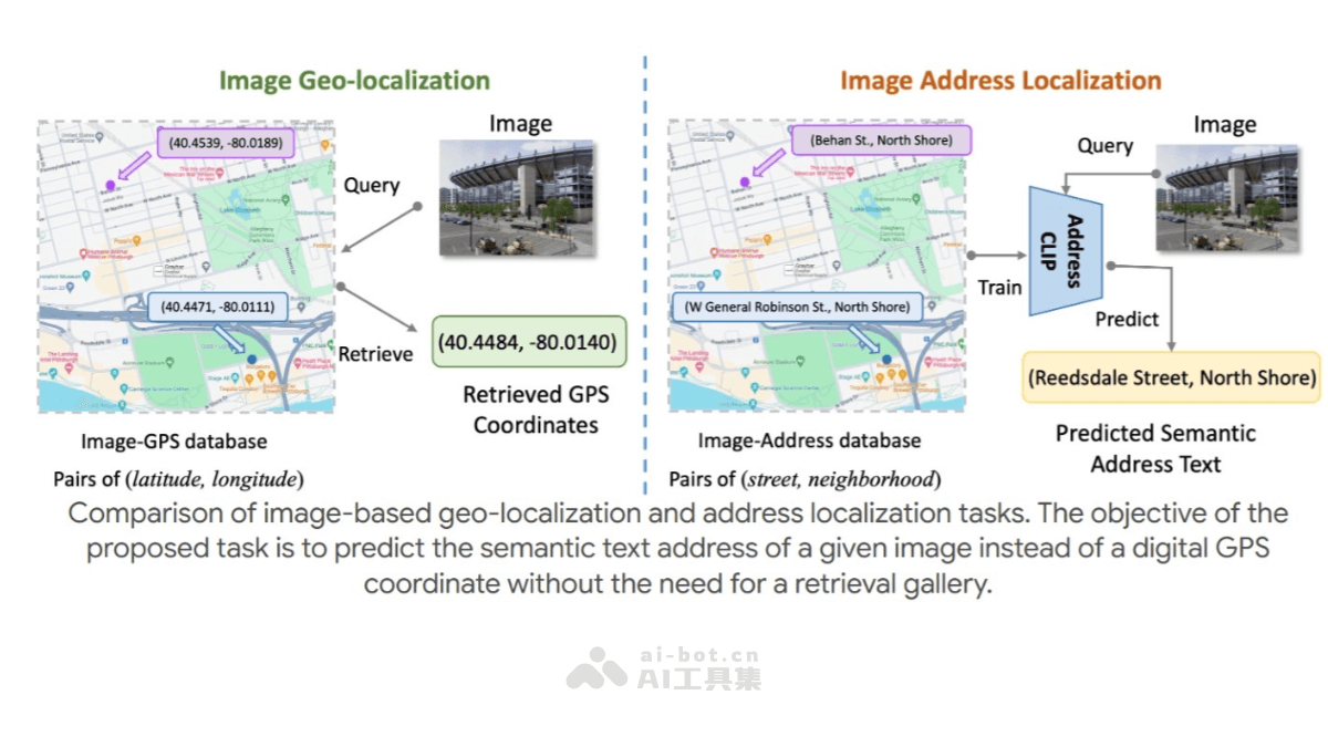
Main Features of AddressCLIP
- End-to-end image geolocation: The model can achieve street-level accuracy localization through a single photo, without relying on complex GPS systems. Through aligning images with address text, it combines image features with geographic information.
- Image-address text alignment: By improving the CLIP training framework, it introduces image-address text contrastive loss, image-semantic contrastive loss, and image-geography matching loss, achieving accurate and uniform image-address text alignment.
- Flexible inference capability: During inference, AddressCLIP can handle candidate address texts in different forms, not limited to the writing conventions in the training set. The model has high flexibility and generalization in practical applications.
- Potential for multimodal integration: It can be combined with multimodal large models for richer question answering related to addresses and geographic information, providing intelligent urban and geographic assistant services.
Technical Principles of AddressCLIP
- Data preparation and preprocessing: Researchers first use multimodal generative models (such as BLIP) to automatically annotate street view images with semantic text, then concatenate these semantic texts with address texts to compensate for the lack of semantic association between images and address texts.
- Improved contrastive learning framework: AddressCLIP improves the CLIP training framework and introduces three loss functions: image-address text contrastive loss, image-semantic contrastive loss, and image-geography matching loss. These loss functions help the model better align image features and address text features.
- Manifold learning and geographic matching: Inspired by manifold learning, the model assumes that two points close in distance in the real geographic environment should also have their addresses and image features close in the feature space. By supervising the distances in the feature space based on the geographic distances between images, the feature space learned by the model becomes more uniform.
- End-to-end inference capability: After training, AddressCLIP can perform inference based on a given set of candidate addresses to identify the shooting location of an image. Since the model aligns images and addresses well during training, it can flexibly handle candidate address texts in different forms during inference.
Project Addresses of AddressCLIP
- Project Website:https://addressclip.github.io
- Github Repository:https://github.com/xsx1001/AddressCLIP
- arXiv Technical Paper:https://arxiv.org/pdf/2407.08156
Application Scenarios of AddressCLIP
- Urban management and planning: In urban inspection and management, staff can quickly identify the specific address information of photos by taking photos and using AddressCLIP. This helps improve the efficiency of urban management.
- Social media and news reporting: On social media platforms, users can upload photos, and AddressCLIP can automatically identify the location where the photo was taken and provide detailed address information.
- Travel and navigation: In the travel sector, tourists can take photos of attractions and use AddressCLIP to obtain detailed addresses and related information about the attractions, allowing them to better plan their itinerary and navigate.
- Location-based personalized recommendations: Combined with multimodal large models, AddressCLIP can be used for location-based personalized content recommendations on platforms such as social media.
- Smart cities and geographic assistants: It can be combined with multimodal large models to provide more intelligent city and geographic assistant services, helping users with question answering related to addresses and geographic information.