
What is ABot-Earth 0.7
ABot-Earth 0.7 is the world's first 3D native city world model launched by Amap. The model adopts a 3D native technical architecture and is trained on spatiotemporal data. With a single satellite image or a piece of text as input, it can generate a kilometer-scale 3D city on a consumer-grade GPU in 10 minutes. The model supports full-scale continuous generation from planets to street views, covering 196+ countries and regions, and users can roam freely and interact in real time. ABot-Earth 0.7 has been deployed in Amap Flying Street View 2.0. As the entry point of Amap's "spatial intelligence", it is evolving toward dynamic perception and spatiotemporal reasoning.
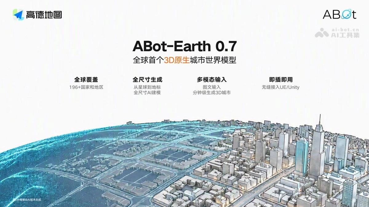
Main features of ABot-Earth 0.7
-
Image-to-3D / Text-to-3D city: Input a single satellite image or a piece of text to generate a kilometer-scale 3D city scene in 10 minutes.
-
Full-scale continuous generation: A single model seamlessly generates from planets to cities and then to street view landmarks, and the spatial structure and visuals remain consistent as the viewpoint zooms in.
-
Free exploration and interaction: It autonomously completes a fully continuous three-dimensional space, allowing continuous entry, free roaming, and real-time interaction, bringing a sense of "presence".
-
Plug and play: The generated results seamlessly integrate with UE/Unity, making it easy for developers to integrate.
-
Flying Street View 2.0 deployment: Users can enter complex buildings and large scenic areas and roam 3D scenes with a joystick.
Technical principles of ABot-Earth 0.7
-
3D native architecture: A model trained on spatiotemporal data covering spatial and temporal information, enabling it to establish a native understanding of three-dimensional space.
-
End-to-end 3DGS generation: It outputs a 3D Gaussian Splatting format scene in one pass, without the need for step-by-step reconstruction.
-
Two-stage generation process: It first generates a sparse structure (occupancy layout), then generates geometry and attributes (active voxel), progressively refining with the satellite image as a condition.
-
Efficiency breakthrough: It produces a kilometer-scale scene on a consumer-grade GPU in 10 minutes, improving efficiency by about 1000 times compared with traditional modes.
How to use ABot-Earth 0.7
-
Official website experience: Visit the ABot-Earth 0.7 official website https://abot-earth.amap.com/,注册登录后即可在线体验。
-
Planet roaming: Open the planet page on the official website to freely browse the Earth, the Moon, Mars, and generated urban three-dimensional spaces.
-
Image-to-3D / Text-to-3D: Upload a satellite image or enter a text description to generate a kilometer-scale 3D city scene.
-
Parcel plaza: Browse and roam three-dimensional parcels shared by others, and intuitively experience the generation quality and roaming experience.
-
Use within Amap: Through the "Flying Street View 2.0" in the Amap App, enter complex buildings and large scenic areas, and control roaming in 3D scenes with a joystick.
-
Engine integration (developers): Import the generated 3DGS results directly into Unity / Unreal Engine, and after adding interaction logic, use them for games, film and television, or digital twin production.
Core advantages of ABot-Earth 0.7
-
The world's first 3D native architecture: It establishes a native understanding of three-dimensional space from the ground up, making it a paradigm-level innovation in digital Earth technology.
-
Extremely high generation efficiency: It generates a kilometer-scale 3D city on a consumer-grade GPU in 10 minutes, improving efficiency by about 1000 times compared with traditional modes.
-
Full-scale continuous generation: A single model covers planet → city → street-level landmarks, maintaining structural and visual consistency when zooming from the overall view to details.
-
World's largest coverage: The digital Earth covers 196+ countries and regions, the broadest coverage to date.
-
Free interactive experience: Autonomously completes continuous 3D space, allowing free roaming and real-time interaction, breaking free from the fixed routes of traditional street view.
-
Deep data moat: Relying on Amap's decade of spatiotemporal data accumulation with nearly one trillion daily BeiDou positioning calls, real-world samples are difficult to replicate.
-
Plug-and-play ecosystem: Seamlessly integrates with UE/Unity and has been deployed in Amap Flying Street View 2.0, with a complete path from experience to commercialization.
Comparison of ABot-Earth 0.7 with similar competitors
| Comparison dimension | ABot-Earth 0.7 (Amap) | Google Earth / 3D Tiles (Google) |
|---|---|---|
| Technical approach | 3D native generation: the model understands 3D space and generates 3DGS scenes end-to-end | Imagery reconstruction: satellite imagery + aerial photography + point cloud collection and stitching |
| Content source | AI generation + autonomous completion, not limited by collected materials | Depends on real captured materials and collection routes; uncovered areas cannot be viewed |
| Generation efficiency | Generates a kilometer-scale 3D city in 10 minutes, about 1,000 times more efficient | Requires professional collection and a months-long reconstruction pipeline; cannot generate instantly |
| Coverage | 196+ countries and regions (AI generation is scalable) | High-definition coverage of major global cities, low accuracy in remote areas |
| Interaction method | Free entry, continuous roaming, real-time interaction, with a sense of "presence" | Mainly browsing; viewpoints and routes are limited by materials |
| Degree of openness | Generated results can be integrated into UE/Unity, open to the developer ecosystem | 3D Tiles has APIs, but generation capabilities are not open to third parties |
| Strategic positioning | Spatial intelligence entry point, evolving toward dynamic perception and spatiotemporal reasoning | Geographic information browsing and map service platform |
Application scenarios of ABot-Earth 0.7
-
Smart travel navigation: Enables 3D real-scene navigation and destination previews in Amap/vehicle systems, letting users enter scenic areas, commercial districts, and complex buildings before departure.
-
Autonomous driving simulation training: Rapidly generates kilometer-scale realistic urban scenes, providing a low-cost, customizable simulation testing environment for autonomous driving.
-
Game and film production: Generates 3D city assets in minutes and integrates with UE/Unity, greatly reducing the cost of virtual sets for open-world games and film production.
-
Digital twins and smart cities: Builds a real-time interactive 3D urban foundation, serving urban planning, traffic governance, and emergency simulation deduction.
-
Culture and tourism and real estate display: Online 3D roaming for scenic areas and museums, property and scenery viewing, as well as a source of spatial perception training data for embodied robots/smart glasses.